|
The I-10 Interstate 10 Highway
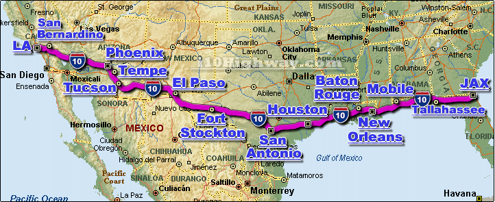
is the main east-west highway automotive transportation corridor along the southern United
States and southern Gulf Coast states. The i-10 acts as a major connector for
major cities, sea-ports, tourism, military, & energy assets located along it's
corridor.
The i-10 is a "trans-continental" highway, meaning it travels across the entire
mainland US from coast-to-coast; from the east coast at
Jacksonville FL, to the west coast
at Los Angeles CA.
The i-10
travels through 8 different US states, including;
Alabama,
Arizona,
California,
Florida,
Louisiana,
Mississippi,
New Mexico, and
Texas.
A number of larger cities are located along the i-10 corridor, including;
Los Angeles CA,
San Bernardino CA,
Phoenix AZ,
San Antonio TX,
Houston TX,
Baton Rouge LA,
New Orleans LA,
Mobile AL,
Pensacola FL,
Tallahassee FL, and
Jacksonville FL.
The i-10 is also known by a number of different names (some depending upon the
region) for example in California, sections of the i-10 are known as the "Santa
Monica Freeway" and the "San Bernardino Freeway", in Houston Texas a section of
the i-10 is known as "the Katy Freeway"... the Highway is also sometimes called
the "Christopher Columbus Transcontinental Highway" and the "Pearl Harbor
Memorial Highway".
The i-10 connects with a number Interstate Highways along its route, including;
in California the i-10 connects with the i-5 and i-15, in Arizona the i-10
connects with the i-8, i-17, and i-19, in Texas the i-10 connects with the i-20,
i-25, i-35, i-37, i-45, in Louisiana the i-10 connects with the i-49, i-55,
i-59, i-37, i-45, in Alabama the i-10 connects with the i-65, and in Florida the
i-10 connects with the i-75 and i-95.
According to the software program Streets & Trips, the program calculates the
entire length of the i-10 at approximately 2,460 miles long, and takes approx.
41 hrs. of full driving time to complete. |


